|
|
|
|
|
| High Country 5-26-16 |
|
| Click to Enlarge |
|
Sattler Mountain Land is selling Alpine and Higher elevation camping and hunting parcels
- listed below. We specialize in this type of property high in the Sangre De Cristo Mountains in Southern Colorado. Click a Link Above for more information about us and to arrive on pages to contact us, reserve
a property, and seek out information about the area, including building codes. You cannot live permanently in this area due
to the high snow fall totals in the winter. We do not show parcels in this area until late April or mid-May at the earliest. You can reserve a parcel sight unseen, but have 30 days to come view it or
proceed to close. Only one reservation per customer if financing We show land all summer and fall by appointment. Use the "contact us"
form or call for an appointment
Additional maps at bottom of page
- click to enlarge all photos. ...
Return to our Properties for Sale
|
|
|
|
|
|
|
|
|
| |
|
|
|
|
|
|
| |
|
|
|
|
|
|
|
70218760
|
Sold to
Alex W. E-3.292.6649
|
|
|
$284
|
$23,400 Cash/Fast-Pay - $26,000 Financed |
|
| |
|
|
|
|
|
|
| |
|
|
|
|
|
|
|
| |
|
|
|
Sold to Alex W. 9/4/2024 SDCR Unit E-3, Block 292, Lot 6649 -- 11,400’
Elevation -- 5.5 Acres. $23,400 Cash or Fast-Pay ($11,400 down and balance paid within 18 months) -- or $26,000
Financed, with $9,800 down and 54 monthly payments of $300. This lot is accessible from approximately
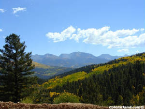
Memorial Day through December. It is located in an area with beautiful alpine meadows and Bristle Cone
Pine stands. This area is a favorite for its commanding views from what feels like the "Top of the World." There is about 100' near the road, with a
less-than-10% slope, that could be used for camping or building.
The lot is approximately 800' in length from the road (elevation 11,400') to the southern corner (elevation 11,260').
In late Auguest and early September, several types of mushrooms grow beneath the trees and in the meadows in this area.
There is a very nice cabin located across Forbes and east of
Moose, but for the most part this area is used for camping and recreating during the warmer months.
Directions to SDCR E3.6649: Please Note: These directions lead to an alpine parcel above 10,000'. This parcel is not
accessible by vehicle with muddy or snowy roads. Portions of Forbes have a very slippery silty
clay surface and it is easy to slide into the ditch. If these conditions are present, please chain
up or forget it. From Fort Garland head south on Colorado Hwy 159 for about 10 miles and after passing
Mile Marker #22, turn left at Jasper Road. Take the next right, go 1/4 mile and turn left at Rito Seco Road. Head
east on Rito Seco for about 5 miles, passing some Battle Mountain Gold Mine buildings on your left. Then turn right
on Forbes Road. Forbes Road is the main road into the high country. Zero odometer as you turn right on Forbes
Road and go up the mountain for about 8.8 miles, just past Moose Road on your right. Lot begins on left side of Forbes
Road and runs about 580 feet along the road to the northwest corner. See plat and gps maps below.
.
| Bristlecones close-up |
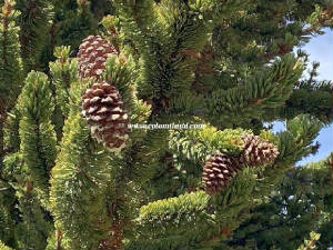
|
| Click for a larger version |
| Plat map |
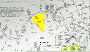
|
| Click for a larger version |
|
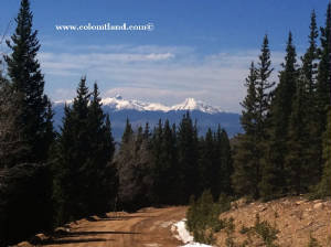
| Opening in Bristlecone Pines |
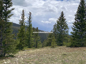
|
| Click for a larger version |
| Aerial map with coordinates |
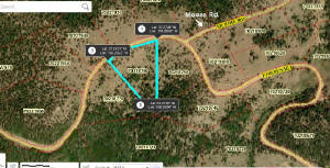
|
| Click for a larger version |
|
| |
|
|
|
Elk Hunting Information
|
Colorado Department of Wildlife
|
| |
|
|
- Alpine Parcels are between 9,500
and 11,600 feet
- Accessible by car or
truck between Memorial Day and New Year's Day
- Steep,
Remote, Hunting areas
- Tall trees, lush
meadows in places, wildlife
- Not suitable
for year-round living
High Country- Memorial Day, 2011 You Tube Video
Click for YouTube Video taken 9/2/16
CONTACT US WITH QUESTIONS - Click
|