|
|
- Five Acre Plus parcels listed in Alphabetical
Order
- Parcels with
power or near power are noted
- Directions
to many of the lots included with their description
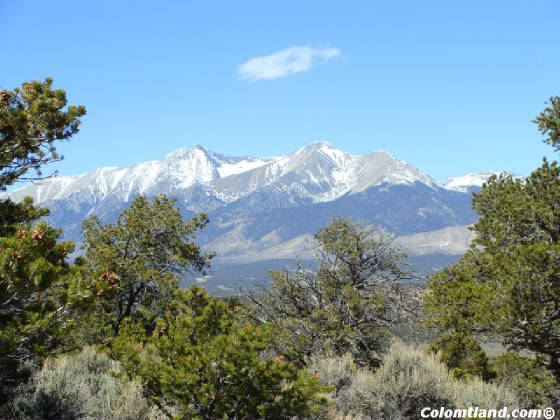
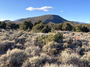
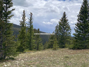
| Unit X - Mountain View From Parcel |
|
|
|
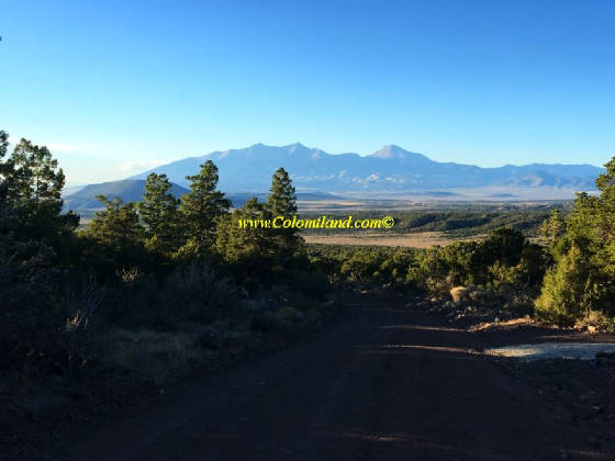
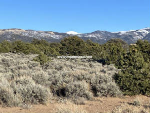
| SDCR Unit L-2 - views and tress - privacy |
|
|
|
|
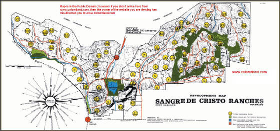
Click on the map shown to the side to see the SDCR area and locate our Sangre
de Cristo Ranch Mountain Land properties for Sale
CLICK- SDCR COVENANTS
Click to view original Forbes Brochure Ad
CLICK TO SEE OUR APPOINTMENT CALENDAR
|
SDCR has covenants and is designed for residences although 90% of it is open and not settled consisting of some
permanent residences and many camping sites
|
It is required to get permits for building from the county - that includes driveways and septic systems
|
There is no regulation which prohibits camping, although recently the county defined the frequency that
you can camp. Sanitation and open fires are an issue. You must follow the county
regulations |
We urge all prospective buyers to read the covenants thoroughly and be familiar with them. We follow them and
we expect you to also, if you purchase from us!
|
|
While you are purchasing land from us, we do not allow building projects,
living on the land, or storing of equipment, supplies, or vehicles. We do allow short-term camping. All county
Rules and Regulations must be followed regarding camping and permitting. If you get our permission, you can put in a
driveway and/or camping pad, with a permit from the county. There might be a few exceptions, such as keeping a fire-pit
on the property which we can allow on an individual basis.
|
|
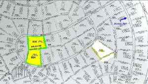
| SDCR Map |
|
| CLICK FOR A LARGER FULL SCALE VERSION |
There are approximately 9,000 parcels of land in SDCR. Click this map to see the UNIT
location of land that you might be interested in
|
|
CONTACT US WITH QUESTIONS - Click
|
| |
|
| |
|
| |
|
| |
|
|
|
New! SDCR Unit D, Block 69, Lot 934 -- 8,200’ Elevation -- 5.163 Acres.
$17,500 Cash -- or $20,000 Financed with $8,500 Down and $250/Month for 46 Months.
-And-
New! SDCR
Unit D, Block 69, Lot 936 -- 8,200' Elevation -- 5.178 Acres. $14,800 Cash -- or $16,800 Financed with $6,300 Down and
$250/Month for 42 Months. Lot #934: South Lot. Features great views, a driveway, large parking/building pad and septic already installed on the lot,
making it ideal for RV camping or a year-round homesite. Lot 936: North Lot. This parcel has a driveway leading to a circular pad near a
concentration of Pinion trees, for a more secluded feel.. There are wonderful views of the San Luis Valley to the West, and both Rattlesnake
Mesa and the Blanca Massif to the North. Mountain Home Reservoir, offering fishing and boating, is about 5 minutes'
drive away. These parcels are ideal for someone looking to build a year-round dwelling, or for a frequently-visited vacation
home. There are several nice, well-kept homes in the area. The town of Fort Garland is a 10-minute drive away, with
a Post Office, grocery store, two gas stations, and a handful of restaurants. Colorado's oldest town, San Luis, is about
15-20 minutes south on highway 159. Alamosa, with a Walmart, hospital, restaurants and other amenities, as about 30
minutes' drive west on U.S. 160.
Directions to SDCR D.934 & 936: From Fort Garland head south on Colorado Hwy 159 for about 4.7 miles, turn left
on County Lane 6. Follow County Lane 6 about 2.5 miles to a 4-way intersection; continue straight onto Juarez Rd. and
drive 1 mile. Turn right on Bateman and drive about 0.35 miles; lot 936 is on left.
Continue on Bateman about 0.4 miles; driveway entrance to lot 934 is on left. See maps below.
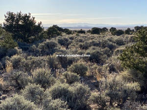
| View of Rattlesnake Mesa and Blanca Massif |
|
| Click for a larger version |
|
| Corner pin, on 934 looking at 936 |
|
| Click for a larger version |
|
| Snow-dusted nearby foothills |
|
| Click for larger version |
|
| Beautiful view across San Luis Valley to the West |
|
| Click for larger version |
|
| Plat map |
|
| Click for a larger version |
|
| Aerial map with coordinates |
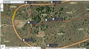
|
| Click for a larger version |
|
| |
|
|
| |
|
|
|
New! SDCR Unit E, Block 77, Lot 995 -- 8,350’ Elevation -- 5.067 Acres. $22,500 Cash --
Or $25,200 Financed with $10,800 Down and $300 for 48 months. This lot is heavily wooded with mature Pinion pines.
It gains about 10-14 feet in elevation from Wilking south to the back of the lot. There are great views of Blanca Massif
and Rattlesnake Mesa from the road and from several potential building areas on the lot. Fort Garland, with it's Post
Office, grocery store, two gas stations, a liquor store, two motels and several restaurants, is about 10 minutes' drive away,
and Mountain Home Reservoir - with fishing and camping - is about 8 minutes away. Alamosa, with a Walmart, hospital,
many restaurants and other amenities, is about 25 minutes' drive west from Fort Garland. Due to its many trees, this
parcel has a secluded feel. There are a few potential building areas that would require a driveway and pad. There
are also many places to pitch a tent for a weekend camping trip.
Directions to SDCR E.995: From Fort Garland head south on Colorado Hwy 159 for about 4.7 miles, turn left on County Lane 6.
Follow County Lane 6 about 2.5 miles to a 4-way intersection; continue straight onto Juarez Rd. and drive 1 mile. Turn
left on Bateman Rd. and drive 0.2 miles, take first right onto Wilking. Zero odometer. Drive 0.45 miles, stop
car. NW corner is on right. See maps below.
| Plat map |
|
| Click for a larger version |
|
| Aerial map with coordinates |
|
| Click for a larger version |
|
| |
|
|
| |
|
|
|
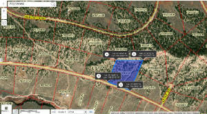
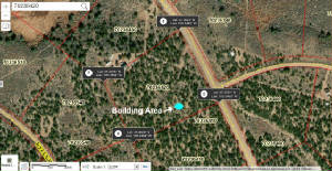
Sold To Alex W. 9/4/2024 SDCR Unit E-3, Block 292, Lot 6649 -- 11,400’ Elevation -- 5.5
Acres. $23,400 Cash or Fast-Pay ($11,400 down and balance paid within 18 months) -- or $26,000 Financed, with $9,800
down and 54 monthly payments of $300.
This lot is accessible
from approximately Memorial Day through December. It is located in an area with beautiful alpine meadows
and Bristle Cone Pine stands. This area is a favorite for its commanding views from what feels like the "Top of the World." There is about 100' near the road, with a
less-than-10% slope, that could be used for camping or building.
The lot is approximately 800' in length from the road (elevation 11,400') to the southern corner (elevation 11,260').
In late July and early August, several types of mushrooms grow beneath the trees and in the meadows in this area.
There is a very nice cabin located across Forbes and east of
Moose, however this area is mostly used for camping and recreating during the warmer months.
Directions to SDCR E3.6649: Please Note: These directions lead to an alpine parcel above 10,000'. This parcel is not
accessible by vehicle with muddy or snowy roads. Portions of Forbes have a very slippery silty
clay surface and it is easy to slide into the ditch. If these conditions are present, please chain
up or forget it. From Fort Garland head south on Colorado Hwy 159 for about 10 miles and after passing
Mile Marker #22, turn left at Jasper Road. Take the next right, go 1/4 mile and turn left at Rito Seco Road. Head
east on Rito Seco for about 5 miles, passing some Battle Mountain Gold Mine buildings on your left. Then turn right
on Forbes Road. Forbes Road is the main road into the high country. Zero odometer as you turn right on Forbes
Road and go up the mountain for about 8.8 miles, just past Moose Road on your right. Lot begins on left side of Forbes
Road and runs about 580 feet along the road to the northwest corner. See plat and gps maps below.
| Bristlecones close-up |

|
| Click for a larger version |
| Plat map |
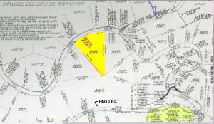
|
| Click for a larger version |
|
| Opening in Bristlecone Pines |
|
| Click for a larger version |
| Aerial map with coordinates |
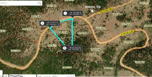
|
| Click for a larger version |
|
| |
|
|
| |
|
|
|
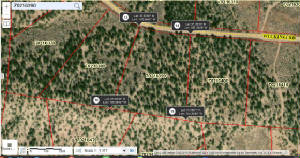
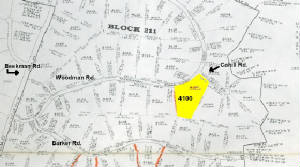
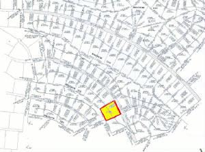
SDCR Unit F-2, Block 212, Lot
4100 -- 5.036 Acres. $8,600 Cash -- or $9,500 Financed, with $3,200 down and 36 monthly payments of $175.
This parcel is located at the corner of Woodman and Cahill,
in an area of the Ranches with amazing views of the Blanca Massif, which seems to tower down from the North. This lot
would be a good place for a permanent dwelling, with easy and reliable year-round access and plenty of potential building
sites. There are a few Pinions but mostly sage brush, with some terrain variation and a seasonal wash toward the back
of the property to make things interesting.
Directions: From the intersection
of U.S. 160 and State Highway 159 in Fort Garland, head East on 160 for 1.8 miles, turn right and pass through the Trinchera
Ranch entrance. Follow paved Trinchera Ranch Rd. about 1.1 miles to a left turn on Beekman. Take Beekman about
2.7 miles, turn right on Woodman Rd. At the fork, stay left to remain on Woodman. From the fork, drive about 0.6
miles to Cahill Rd., which turns to the right. Park car, lot is on the right, on the Southwest corner of Woodman and
Cahill. See plat and gps maps below.
| Plat map |
|
| Click for a larger version |
|
| Aerial map with coordinates |
|
| Click for a larger version |
|
| |
|
|
| |
|
|
|
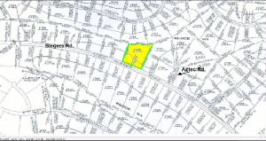
New! SDCR
Unit J, Block 113, Lot 1729 -- 5.274 Acres. $15,000 Cash -- Or $16,800 Financed
with $7,300 Down and $250/month for 38 months.
This parcel is moderately wooded with
Pinion Pines and has nice views of San Luis Valley and surrounding ridges. Blanca Massif is visible from the higher
parts of the lot. Mountain Home Reservoir is less than 10 minutes drive away. There are several potential building
spots, which require the installation of a driveway and pad. With the right vehicle and a little shovel work, it would
be possible to drive off tthe road and pitch a tent. There is a neighbor across Slegers and a little bit west, near
Ojito Creek.
Directions: From Fort Garland head south on Colorado Hwy 159 for about 4.7 miles, turn left on County
Lane 6. Follow County Lane 6 about 2.5 miles to a 4-way intersection; turn left to stay on County Lane 6 and drive 0.9
miles. Turn right on Luke, then take first right onto Slegers. Zero odometer and drive 3.3 miles. Lot is
on left, two lots west of Aztec. See plat and aerial gps maps below.
.
| Plat map |
|
| Click for a larger version |
|
| Aerial map with coordinates |
|
| Click for a larger version |
|
| |
|
|
| |
|
|
|
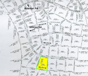
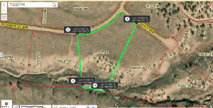
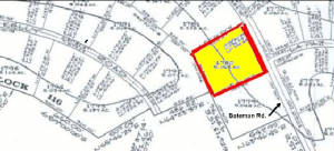
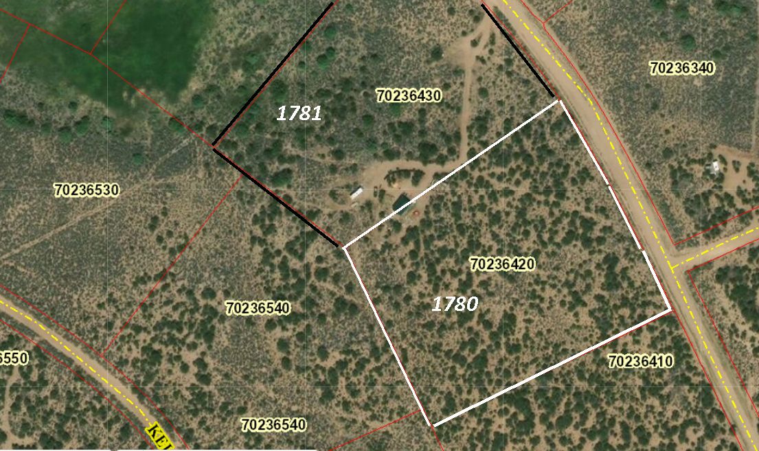
Price Reduced! SDCR Unit J, Block 115, Lot 1780 -- 5.158 Acres. $13,000 $12,400
Cash -- or $14,600 $14,000 Financed, with $5,500 down and 34 monthly
payments of $250.
This parcel is heavily wooded with Pinion Pines and has nice views of both
the Blanca Massif and Rattlesnake Mesa, which is located next to Mountain Home Reservoir, about 8 minutes away. A partial
driveway and potential building area are already on the lot (see aerial photo below), although a professionally installed
culvert will be required for access to Bateman Rd. There is a building area with great views of Mt. Blanca located on
the southern half of the parcel. With all the Pinions, there is a sense of seclusion and quiet. Please note that
a neighbor to the West appears to have built his home so that it straddles the boundary line -- (see aerial photo below). Directions: From Fort Garland
head south on Colorado Hwy 159 for about 4.7 miles, turn left on County Lane 6. Follow County Lane 6 about 2.5 miles
to a 4-way intersection; continue straight onto Juarez Rd. and drive 1 mile. Turn left on Bateman Rd. and drive 1.4
miles and park across from La Paz Rd. Lot is on the right. See plat and aerial gps maps below.
| Plat map wide view |
|
| Click for a larger version |
|
| Aerial map with coordinates |
|
| Click for a larger version |
|
| |
|
| Plat map closer view |
|
| Click for a larger version |
|
| Aerial map showing building area and neighbor |
|
| Click for a larger version |
|
| |
|
|
| |
|
|
|
|
| |
|
| |
|
| |
|
|
|
|
| |
|
| |
|
| |
|
| |
|
Wooded Properties South East of Fort Garland, CO Lots for vacation homes, log cabins, travel trailer or RV. Reasonably priced Colorado Real Estate with owner financing.
|