|
|
|
|
|
|
- You can reserve a parcel sight unseen, but have 30 days
to come view it or proceed to close
- Only one reservation
per customer
- Parcels marked with a "range" of
pricing are because we haven't seen them yet but will price them soon
- We
show land all summer and fall by appointment. Use the "contact us" form or call for an appointment
- Additional maps at bottom of page - click to enlarge all photos
|
|
|
|
|
|
|
|
|
|
70205780
|
|
|
9,500'
|
$133
|
$15,500 Cash- $17,000 financed |
Greenbelt more than two miles away- see full listing below |
|
70206760
|
B-3. 284.6387
|
5.48 Acres
|
9,572'
|
|
$11.5K Cash - $12.8K financed
|
Greenbelt more than two miles away
|
|
70218890
|
E-3.293.6616
|
|
11,200'
|
|
$12K Cash- $15K financed
|
Greenbelt more than two miles away
|
|
70219100
|
|
7.05 Acres
|
10,400'
|
$186
|
$13.5 Cash- $15k financed
|
Greenbelt more than two miles away
|
|
70253920
|
|
5.02 Acres
|
10,250'
|
|
$10.8k Cash - $12k financed
|
Access via Popp Rd. or Crossman Rd.
|
|
|
|
5.02 Acres
|
|
$151
|
$13.5 Cash- $15k financed
|
Treasurer's Deed-(2001) Surrounded by large Greenbelt Area- see full listing below Reserved 7-18-15
|
|
70262840
|
|
|
10,200'
|
$126
|
$12,600 Cash - $14K financed
|
Two Miles to large Greenbelt Area
|
|
70274710
|
|
|
9,520'
|
$160
|
$15.3K Cash or $17K Financed |
Treasurer's Deed-Surrounded by large Greenbelt Area
|
|
70275070
|
|
5.01 Acres
|
10,000'
|
$160
|
$13.8K Cash, $15.3K Financed |
One Mile to Greenbelt Access Point
|
|
70275110
|
|
5.33 Acres
|
|
|
$13.8K Cash, $15.3K Financed |
Two miles from Greenbelt Access Point
|
| |
|
|
|
|
|
|
| |
|
|
|
|
|
|
| |
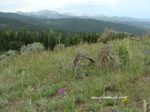
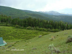
- Alpine Parcels are between 9,500
and 11,600 feet
- Accessible by car or
truck between Memorial Day and New Year's Day
- Steep,
Remote, Hunting areas
- Tall trees, lush
meadows in places, wildlife
- Not suitable
for year-round living
High Country- Memorial Day, 2011 You Tube Video
| |
|
|
Elk Hunting Information
|
Colorado Dept. of Wildlife- Hunting Information
|
| |
|
|
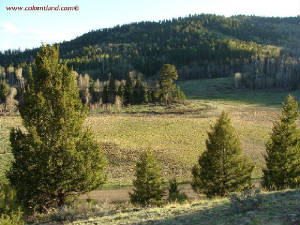
| View across from top across road |
|
| Click to enlarge |
|
| View from the General Area |
|
| Click to enlarge |
|
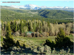
| Trinchera View |
|
| Click to enlarge |
|
| Showing the neighbor's at top of crest |
|
| Click to enlarge |
|
| Meadow view uptop |
|
| Click to enlarge |
|
| Another view of the parcel from above |
|
| Click to enlarge |
|
| |
|
|
SDCR Unit B-3, Block 278, Lot 6281 -- 9,450’ Elevation
-- 5.42 Acres. $15,500 Cash or Fast-Pay( finish paying in 2 years - $6,000 down). $17,000 with longer
term financing. $6,000 down and 55 monthly payments of $200. This lot is accessible from Memorial Day through
December. It is located in an area with beautiful alpine meadows. This area is a favorite among the locals and there are several
cabins nearby. This parcel has several,
nearly flat areas near the road and can be used for camping immediately. It has a gently sloping, rounded top with a
gorgeous view towards Trinchera Peak and the Sangre De Cristo Mountains south of US 160. The elevation is 9,540'. There is a steep 4-WD road going
to the top of the property. To change that to a 10% grade will require a winding drive about 800' long and estimated
to cost $2,000.
There are
an estimated 60 cabins above 9500’ and people use solar panels for power, septic systems for waste and buried cistern
for water. Propane is used for cooking and heating. Most alpine cabins will also have a wood stove. Propane and water delivery
is available, but owners often haul their own water. Water can be hauled with trailer mounted tank (300-500 gallons) and these
tanks can be filled at the San Luis Water Department. High Country wells are common in Forbes Park, but to my knowledge, there
are none above 9500’ in the SDCR.
Directions to SDCR B.3.6281Please
Note: These directions lead to an alpine parcel above 9,500'. This parcel is not accessible by vehicle with muddy or snowy
roads. Portions of Forbes and Malcolm have a very slippery silty clay surface and it is easy to slide into
the ditch. If these conditions are present, please chain up or forget it. From Fort Garland head south on Colorado Hwy 159 for about
10 miles and after passing Mile Marker #22, turn left at Jasper Road. Take the next right, go 1/4 mile
and turn left at Rito Seco Road. Head east on Rito Seco for about 5 miles, pass some Battle Mountain Gold
Mine buildings on your left. Then turn right on Forbes Road. Forbes Road is the main
road into the high country. Zero odometer as you turn right on Forbes Road and go up the mountain for about
3.8 miles. Turn right at wooden sign "Sangre de Cristo Ranches." Zero odometer
again as you turn right. Take the left fork at the next intersection and after that, take the next left
fork again. Then take the next right and continue on Malcolm for 2.3 miles and stop vehicle at Malcolm
and Jaquez. Lot 6281 will be on your left.
.
|
|
| GPS Coordinates and boundaries |
|
|
| Click to enlarge |
|
|
| |
|
|
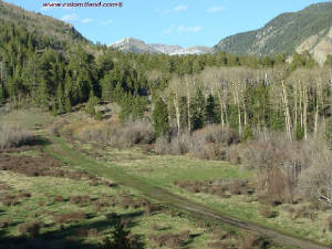
| Aspens along Jacquez |

|
| Click for larger version |
|
| Culvert-fed flowing stream below Jacquez |

|
| Click for larger version |
|
| Neighbor's driveway across Jacquez |

|
| Click for larger version |
|
| Stream and lush green toward center of lot |

|
| Click for larger version |
|
| Mossy rock beside stream |

|
| Click for larger version |
|
| Beautiful twin pines on parcel |

|
| Click for larger version |
|
| Lot is on the right, where Wolfgang is looking |

|
| Click for larger version |
|
| Corner marker along Jacquez |

|
| Click for larger version |
|
|
SDCR Unit B-3, Block 284, Lot 6387 -- 9,560’ Elevation
-- 5.48 Acres. $11,500 Cash or Fast-Pay (finish paying in 1 year - $4,500 down). $12,800 with
longer term financing. $3,500 down and 48 monthly payments of $205.
This lot is accessible from Memorial Day through December. It
is located in an area with beautiful alpine meadows. This area is a favorite among the locals and there are several cabins
nearby. This parcel is
heavily treed with a culvert-fed stream running through the middle. There is a fairly level area for building below Jacquez
and above the stream. The lot runs over 700 feet to the back boundary, which is 300 feet across. The elevation here is between
9,500 and 9,600 feet. There are an estimated 60 cabins above 9500’
and people use solar panels for power, septic systems for waste
and buried cistern for water. Propane is used for cooking and heating. Most alpine cabins will also have a wood stove. Propane
and water delivery is available, but owners often haul their own water. Water can be hauled with trailer mounted tank (300-500
gallons) and these tanks can be filled at the San Luis Water Department. High Country wells are common in Forbes Park, but
to my knowledge, there are none above 9500’ in the SDCR. Directions: Please Note: These directions lead to an alpine parcel above 9,500'. This parcel is not accessible
by vehicle with muddy or snowy roads. Portions of Forbes and Malcolm have a very slippery silty clay surface and it
is easy to slide into the ditch. If these conditions are present, please chain up or forget it. From Fort Garland head south on Colorado Hwy 159
for about 10 miles and after passing Mile Marker #22, turn left at Jasper Road. Take the next right, go 1/4 mile and
turn left at Rito Seco Road. Head east on Rito Seco for about 5 miles, passing some Battle Mountain Gold Mine buildings on your left. Then turn right on Forbes Road.
Forbes Road is the main road into the high country. Zero odometer as you turn right on Forbes Road and go up the mountain
for about 3.8 miles. Turn right on Malcolm Rd. Take
the left fork at the next intersection and after that, take a right at the next fork. Drive
to Barbara road, stop the car, zero odometer. After 0.2 miles, park. Lot begins on left side of road, following turn in
road – see plat map. Corners are marked with blaze tape. .
| Plat map |
|
|
| Click for a larger version |
|
| GPS Coordinates and boundaries |
|
|
| Click for larger version |
|
|
| |
|
|
| Looking up Popp Rd. |

|
| Click for larger version |
|
| Beautiful Aspen, Pine and ground cover off Popp |

|
| Click for larger version |
|
| View down Crossman toward Bisson |

|
| Click for larger version |
|
| Flat area off Crossman |

|
| Click for larger version |
|
| Crossman seen from flat area |

|
| Click for larger version |
|
| Natural opening for possible driveway |

|
| Click for larger version |
|
| |
|
|
SDCR Unit N-2, Block 243, Lot 5232 -- 10,250’ Elevation
-- 5.016 Acres. $10,800 Cash or Fast-Pay. $12,000 Financed, with $3,000 down and 50 monthly
payments of $180. This
lot is accessible from Memorial Day through December. The lot is heavily treed with Aspen and Pine, with a flat area for building
off Crossman. We found a natural opening between the Aspen trees that would allow a short driveway back into a
clearing. Deer and elk populate the area, making this a nice hunting parcel.
There are an estimated 60 cabins above 9500’ and people use solar panels for power, septic systems for
waste and buried cistern for water. Propane is used for cooking and heating. Most alpine cabins will also have a wood stove.
Propane and water delivery is available, but owners often haul their own water. Water can be hauled with trailer mounted tank
(300-500 gallons) and these tanks can be filled at the San Luis Water Department. High Country wells are common in Forbes
Park, but to my knowledge, there are none above 9500’ in the SDCR.
Directions: Please Note: These directions lead to an alpine parcel above 9,500'. This parcel is not accessible by vehicle with
muddy or snowy roads. Portions of Slegers and Popp have a very slippery silty clay surface and it
is easy to slide into the ditch. If these conditions are present, please chain up or forget it.
From Fort Garland head south on Colorado Hwy 159 for 4.7 miles to Mile Marker #29, turn left onto County
Lane 6. Drive 2.5 miles to 4-way intersection; turn left, remaining on County Ln. 6. Take next right onto
Luke; then take first right onto Slegers. Stop car, zero odemeter, then drive 7.1 miles on Slegers to a right turn on
Popp. At fork, go left to remain on Popp. At intersection with Crossman, you can either stay on Popp or turn right
onto Crossman -- lot is bordered by both roads. Along Popp, lot begins about 0.15 miles from Crossman; along Crossman,
lot begins about 0.18 miles from Popp. See maps below. Lot has been marked with blaze tape on each of the corners. .
| Plat map |
|
|
| Click for larger version |
|
| Aerial map with coordinates |
|
|
| Click for larger version |
|
|
| |
|
|
| Property on left with Gold trees |
|
|
| Click to Enlarge |
|
| Property on right - Warner Rd - gold trees |
|
|
| Click to Enlarge |
|
| Vehicle access up into property |
|
|
| Click to Enlarge |
|
| Another view of the vehicle access |
|
|
| Click to Enlarge |
|
| View towards Bateman |
|
|
| Click to Enlarge |
|
| Wolfgang on Warner- Bateman curling behind |
|
|
| Click to Enlarge |
|
| Tall trees- Sangre de Cristos behind for view |
|
|
| Click to Enlarge |
|
| Photos of the parcel in October, 2014 |
|
|
| Click to Enlarge |
|
|
Reserved Derek B. 7-18-15 SDCR Unit Q-2, Block 237, Lot 5100 -- 9,840’ Elevation
-- 5.02 Acres. $13,500 Cash or Fast-Pay( finish paying in 2 years - $6,000 down). $15,000 with longer
term financing. It had been a tax certificate in 2001, but had been sold and re-repurchased to a customer in the interim.
This lot is covered with aspen and pine trees and located
near the top of a ridge at an Elevation of 9,840'. This property
has a driveway and camping pad. It is in an elk hunting
area with great views and open, alpine meadows. There is a Greenbelt adjacent to the north boundary. Directions: From Fort Garland head south on Colorado Highway 159 for 7 miles and turn left near Mile Marker 26. Head east on
Camino Tio Ervin for about 3 miles and turn right on Juarez Rd. Zero odometer as you turn. Head south on Juarez for almost0.4
miles, turn left at Michaels and the take the next left on Joy. Zero odometer again and after odometer 2.3, turn left on Bateman.
Head up the mountain and around Odometer 3.2 stop vehicle at Bateman and Warner. Lot is bordered by Warner
on the south for almost 800'. Later, go up Warner to the end for a super view.
.
|
| Plat Map with property in RED |
|
|
| Click to Enlarge |
|
| Enlargement of Official Quadrant Map |
|
|
| Click to Enlarge |
|
|
| |
|
|
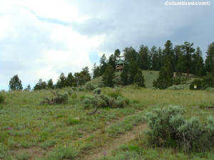
| Property on right of Yeevers Rd |
|
|
| Click to Enlarge |
|
| Mike put in a marker with blaze on boundary |
|
|
| Click to Enlarge |
|
| Looking up to the tall trees at the parcel |
|
|
| Click to Enlarge |
|
| On parcel looking toward Yeevers Rd |
|
|
| Click to Enlarge |
|
| Parcel on the right side |
|
|
| Click to Enlarge |
|
| Karen at center of parcel - looking to start up |
|
|
| Click to Enlarge |
|
| Looking across upper access- terrain |
|
|
| Click to Enlarge |
|
| Another photo from upper parcel |
|
|
| Click to Enlarge |
|
|
SDCR Unit T-2, Block 252, Lot 5584--5.3 Acres--$12,600 Cash or Fast-Pay.
If you select Fast-Pay, we require $4,600 down and 20 monthy paymnts of $400. Our financed option price is $14,000 with
$3,000 down and 60 monthly payments of $184 Unit T is a remote area mostly above 10,000'. Lot 5584 has aspen, spruce and fir trees, but
also a nice mixture of meadow areas on the property, which is perfect for elk hang-outs. The lot slopes
up-hill with two gently sloped parking/building/camping spots. As the crow flies - it is about a mile to the Greenbelt.
Directions: From Fort
Garland Head south on CO 159 for 7 miles and turn Left near Mile Marker # 26. Go east on Camino Tio Ervin for 3+ miles and
turn right on Juarez Rd. Zero odometer as you turn. Go south on Juarez for 2.8+ miles and the take the next left on
Balleroy. Zero odometer as you turn. Head up-hill for 4.3+ miles. After odometer 4.2 look for a four way intersection (Balleroy,
Slegers, Loubiers and Sands). Zero odometer again at that intersection. Take a left on Loubiers. From
Loubiers take the next left on Folansbee and then the next right on Yeevers. Stop vehicle as odometer turns over 0.7. Lot
5584 will be on your right and you should be near the center of the lot.
| Google Earth image with parcel marked |
|
|
| Click to Enlarge |
|
| Quadrant map showing parcel in red |
|
|
| Click to Enlarge |
|
|
| |
|
| |
|
| Aspens and pine |
|
|
| Click for larger image |
|
| Nice clearing back from the road |
|
|
| Click for larger version |
|
| View from clearing back toward Bruce Road |
|
|
| Click for larger version |
|
| Larger pines on lot |
|
|
| Click for larger version |
|
| Another clearing, this one near big pines |
|
|
| Click for larger version |
|
| Aspens and lush green vegetation |
|
|
| Click for larger version |
|
| Lot on left, view toward cul-de-sac |
|
|
| Click for larger version |
|
| Old fire pit in clearing on northeast part of lot |
|
|
| Click for larger version |
|
|
SDCR Unit Y-2, Block 265, Lot 6026 -- 5.64 acres -- Cash/FastPay
price: $15,300 -- Financed price: $17,000, with $4,250 down and 60 monthly payments of $225. This lot, which butts up against a large swatch of Greenbelt
common land, is located along Bruce Road at 9,490 feet, ending at the cul-de-sac. It is well-treed and is relatively
flat along the road, going back a hundred feet or more onto the lot. There are several areas for a potential building
spot. There are an
estimated 60 cabins in the alpine areas of the SDCR above 9,500', and people use solar panels
for power, septic systems for waste and buried cistern for water. Propane is used for cooking and
heating. Most alpine cabins will also have a wood stove. Propane and water delivery is
available, but owners often haul their own water. Water can be hauled with trailer mounted tank (300-500
gallons) and these tanks can be filled at the San Luis Water Department. High Country
wells are common in Forbes Park, but to our knowledge, there are none above 9500’
in the SDCR. Directions:
Please Note: These directions lead
to an alpine parcel above 9,500'. This parcel is not accessible by vehicle when the roads are muddy
or snowy. Portions of Forbes have a very slippery, silty clay surface and it is easy
to slide into the ditch. If these conditions are present, please
chain up or forget it. From Fort Garland head south on Colorado Hwy 159 for about 10 miles and after
passing Mile Marker #22, turn left at Jasper Road. Take the next right, go 1/4 mile
and turn left at Rito Seco Road. Head east on Rito Seco for about
5 miles, pass some Battle Mountain Gold Mine buildings on your left. Then turn right
on Forbes Road. Forbes Road is the main road into the high country.
Zero odometer as you turn right on Forbes Road and go up the mountain for about 3.2 miles.
Turn left on Wood Road, then drive to second left at Bruce Road. Lot begins on left, 308 feet along Bruce to
beginning of cul-de-sac. See plat map and aerial map for exact location.
| Plat map |
|
|
| Click for larger version |
| Aerial map with coordinates |
|
|
| Click for larger version |
|
| |
|
| Property on corner of Forbes and Vreeland |
|
|
| Click to Enlarge |
|
| Driveway area - west off Forbes Rd |
|
|
| Click to Enlarge |
|
| Drive area off Vreeland -- second driveway |
|
|
| Click to Enlarge |
|
| View across Forbes from intersection |
|
|
| Click to Enlarge |
|
| Mixed Pines and Aspen trees on lot |
|
|
| Click to Enlarge |
|
| Snow in mid-May |
|
|
| Click to Enlarge |
|
| |
|
|
SDCR Unit Y-2, Block 265, Lot 6062 -- 5.01 acres -- Cash/FastPay
price: $13,800 -- Financed price: $15,300, with $3,825 down and 60 monthly payments of $210. This lot, located at the corner of Forbes Rd. and Vreeland,
has two driveways already installed. It has a beautiful view of the Trinchera Peak area across Forbes. Elevation
at the intersection is 10,000 feet. This property is populated by deer and elk, is wooded with pines and Alpine and has
several buildable areas that are available for immediate camping. There are an estimated 60 cabins in the alpine areas of the SDCR above 9,500',
and people use solar panels for power, septic systems for waste and buried cistern
for water. Propane is used for cooking and heating. Most alpine cabins will also have a wood
stove. Propane and water delivery is available, but owners often haul their own water.
Water can be hauled with trailer mounted tank (300-500 gallons) and these tanks can
be filled at the San Luis Water Department. High Country wells are common in Forbes Park, but to our
knowledge, there are none above 9500’ in the SDCR. Directions: Please Note: These directions lead to an alpine parcel above 9,500'. This
parcel is not accessible by vehicle when the roads are muddy or snowy. Portions
of Forbes have a very slippery, silty clay surface and it is easy to slide into the ditch.
If these conditions are present, please chain up or forget it. From Fort Garland head south on Colorado Hwy
159 for about 10 miles and after passing Mile Marker #22, turn left at Jasper Road.
Take the next right, go 1/4 mile and turn left at Rito Seco Road.
Head east on Rito Seco for about 5 miles, pass some Battle Mountain Gold Mine
buildings on your left. Then turn right on Forbes Road. Forbes Road
is the main road into the high country. Zero odometer as you turn
right on Forbes Road and go up the mountain for about 4 miles. Turn left on Vreeland, park car; lot
is on the northwest corner, stretching 574 feet along Vreeland.
| Plat map |
|
|
| Click for larger version |
|
| |
|
| Trees along Vreeland looking toward south |
|
|
| Click for larger version |
|
| View down Vreeland looking north |
|
|
| Click for larger version |
|
| Trees and ground cover at center of lot |
|
|
| Click for larger version |
|
| Tall pines on lot |
|
|
| Click for larger version |
|
| Clearing for possible building area |
|
|
| Click for larger version |
|
| Aspens along Vreeland |
|
|
| Click for larger version |
|
| |
|
|
SDCR Unit Y-2, Block 265, Lot 6067 -- 5.33 acres -- Cash price:
$13,800 -- Financed price: $15,300, with $3,825 down and 60 monthly payments of $210. This alpine lot is thickly wooded with Aspens and pines, located
1/4 mile down Vreeland from Forbes Road. Elevation is about 9,900 feet and is accessible from Memorial Day through December.
There are beautiful alpine meadows in the area, which is populated by deer and elk. This parcel has several clearings
and flat areas that can be used for camping or building immediately. There are an estimated 60 cabins in the alpine areas of the SDCR above 9,500', and people use solar
panels for power, septic systems for waste and buried cistern for water. Propane is used for cooking and
heating. Most alpine cabins will also have a wood stove. Propane and water delivery is available, but
owners often haul their own water. Water can be hauled with trailer mounted tank (300-500 gallons) and these
tanks can be filled at the San Luis Water Department. High Country wells are common in Forbes Park, but to our
knowledge, there are none above 9500’ in the SDCR. Directions:
Please Note: These directions lead to an
alpine parcel above 9,500'. This parcel is not accessible by vehicle when the roads are muddy or snowy. Portions
of Forbes have a very slippery, silty clay surface and it is easy to slide into the ditch.
If these conditions are present, please chain up or forget it. From Fort Garland head south on Colorado Hwy 159 for about
10 miles and after passing Mile Marker #22, turn left at Jasper Road. Take the next
right, go 1/4 mile and turn left at Rito Seco Road. Head east on Rito Seco for about
5 miles, pass some Battle Mountain Gold Mine buildings on your left. Then turn right
on Forbes Road. Forbes Road is the main road into the high country. Zero
odometer as you turn right on Forbes Road and go up the mountain for about 4 miles. Turn left on Vreeland;
zero odometer again. Drive 0.5 miles, then look on left side of road for orange
blaze tape markings at corners. See plat map for details.
| Plat map |
|
|
| Click for larger version |
|
| |
|
|
Additional Maps
|
| |
CONTACT US WITH QUESTIONS - Click
Sub-Alpine Properties
|


