• Sub-Alpine Parcels are between 8,800 and 9,500 feet
  • Accessible by car or truck nearly year-round
  • Somewhat remote, with hunting areas nearby
  • Many lots feature a combination of tall trees and native brush

CONTACT US WITH QUESTIONS - Click

Alpine Parcels For Sale - Click

 
Q.view.jpg
 

Northern view; Mt. Lindsey, Hwy 160 below
G2.4427.01.jpg
Click for larger version
Terrain of parcel - looking towards La Veta
G2.4427.06.jpg
Click for larger version
Pine Trees and tall vegetation on lot
G2.4427.11.jpg
Click for larger version
Neighbor with Park Model home
G2.4427.13.jpg
Click for larger version
A full northern view showing all the mountains
G2.4427.20.jpg
Click for larger version
Perrugia frontage view
G2.4427.23.jpg
Click for larger version

SDCR Unit 
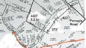
G-2, Block 217, Lot 4427---5.21 Acres-- $11,000 with our financing with $4,000 Down and then $150/mo for 63 months.  Cash and Fast Pay Price is $9,900

...

Located about 2.5 from US Highway 160 Mile Marker 268 (Forbes Park exit with flashing yellow light), at an elevation of 8,870 feet, this is one of the nicest lots in our inventory.  This parcel has a fantastic view of the Blanca Massif, with four 14,000’ plus peaks and the Valley in between.  It also has a great view east toward La Veta Pass.  It has a nice stand of tall, ponderosa pines.  There are two permanent residences in that area, where people live all year, but we do not recommend this location for a permanent or retirement home.  It is much better suited for a cabin or camping spot.  We have several nice, treed view lots available closer to town with much better winter access.  There are no utilities and the people up there use solar panels with batteries and converters, propane tanks, wood stoves, cell phones and satellite internet and TV.  Most people with cabins will take a few canisters of water with them. Permanent residents will usually have a well or buried water tank.  There is a "Park Model" cabin next door with a green roof (visible in a photo).
..
Directions: From Interstate 25, Exit 52 head west on US 160 through Walsenburg for about 41 miles and after Mile Marker # 269, look for Forbes Park Exit with flashing yellow light on your left.From Fort Garland head east on US 160 for about 9 miles and look for Forbes Park sign on your right. Exit, cross railroad track and turn right on Beekman Rd. Zero odometer as you turn right.  Head west on Beekman for almost 0.7 miles and turn left on Marraine Rd. Head up on Marraine and near odometer 2.0, turn right on Clausen road.  Zero odometer again as you turn on Clausen. Head west on Clausen, pass Perrugia and stop car when odometer turns over 0.5 miles.Lot 4427 will be on your right and you will be near the center of the parcel.  If you have a GPS, the coordinates near the center are 37.48423 and -105.31867.  Lot 4427 has 373’ frontage  on Clausen and the lot is over 450’ deep.

Plat Map detail showing property boundaries
4427.plat.jpg
Click for larger version
 

Corner marker at top of property, along Beekman
H2.4552.corner.marker.jpg
Click for larger version
Fiber optic cable on property
4552.b.jpg
Click for larger version
Wolfgang taking in the view from the driveway
4552.c.jpg
Click for larger version
Driveway turns left toward building pad
4552.d.jpg
Click for larger version
Driveway seen from building pad
H2.455212.jpg
Click for larger version
Wolfgang and Mike taking in view from building pad
H2.455211.jpg
Click for larger version

SDCR Unit H-2, Block 217, Lot 4552 -- 5.01 Acres -- Cash Price is $9,900.  Fast-Pay-Price  is $9,900 with $3000 down and the entire $9,900 paid without interest within 12 months.  Financed price is $11,000 with $3,000 down and $175/mo for 60 months.
Check this out as a great parcel not far from the Forbes Park entrance off US 160.  (Mile Marker # 268)  It has nice 60' tall ponderosa pines and year-round access.  There is a permanent resident less than 1/4 mile away and a second family up on Marraine Rd, about 1 mile away.  At an elevation of 8,800' --this lot features a 700 foot long driveway, all the way from Beekman Rd to a camping and parking pad in the shade of two ponderosa's. 


Directions:  From Ft. Garland head east on Highway 160 for about 10 miles to the Forbes Park Entrance, on the right side of the road.  Cross the railroad tracks and turn right onto Beekman.  Zero your odometer.  Follow Beekman about 2.35 miles to a driveway entrance on the left side of the road.  The driveway winds down onto the property, ending at a parking pad with a wonderful mountain view.

Plat map -- lot is highlighted in green
H-2.Plat.jpg
Click for larger version
 

Wildflowers in the foreground
4555.d.jpg
Click for larger version
Blanca Massif in the distance
J2-221-4555-9.jpg
Click for larger version
View to the west, toward the San Luis Valley floor
4555.e.jpg
Click for larger version
Mike taking in mountain views
J2-221-4555-3.jpg
Click for larger version
Another vew toward the west
4555.West.jpg
Click for larger version
Wildflowers near building area at top of lot
4555.f.jpg
Click for larger version

SDCR, UNIT J-2, BLOCK 221, LOT 4555 -- 5.056 Acres.   Cash price:  $6,500.  Financed price: $7,200 with $3,200 Down and then $140 per month for 34 months.  This parcel can be purchased with our Fast-Pay Option, without interest if the entire Cash amount is paid within one year

This parcel is located about 10 miles east of Ft. Garland and 3 miles from paved Colorado Highway 160.  It has a stunning view of the Blanca Massif and Mt. Lindsey, as well as the Valley. This lot has a flat area at the top, and is ready for camping or building.

 
Directions:  From Ft. Garland head east on US 160 for about 10 miles to the Forbes Park entrance.  Cross the railroad tracks and turn right onto Beekman.  Take the second left at Spring Rd.  Follow Spring Rd. for about 2.5 miles, winding higher and higher in elevation.  At McGillicuddy turn right and go 0.4 miles to Callahan.  The lot begins on the northwest corner of McGillicuddy and Callahan (elevation 9,055 feet), extending about 300 feet along Callahan and down the hill northward to a ravine that is visible from the road.

Plat map showing property boundaries
4555.J2.Plat.jpg
Click for larger view
 

Photo taken Mid September, 2010
Q.jpg
Click for larger size
q1e.jpg
Click for larger size
q1d.jpg
Click for larger size
q1c.jpg
Click for larger size
q.1a.jpg
Click for larger size
Plat Map of the six parcels on Weller
Q.plat.jpg
Click for larger version

Driving Directions to the Q Lots

Driving Directions to the Q lots
Q.directions.jpg
Click for larger view
Lower lots 2649, 2650 and 2651 sold to Melissa & Tom, Wisconsin 1/18/12
Upper lots 2646, 2647 and 2648 are reserved by Mike L from Louisiana 4/20/12 
.
SDCR Unit Q, Block 148, Lots 2646, 2647, 2648-- Three  side-by- side parcels all 5+ acres totaling 15+  acres.   These three parcels are available for $23,400 cash or fast-pay. Our Fast-Pay-Option requires $7,400 down followed by eight quarterly payments of $2000.  There is no interest with this option.
These parcels border the 170,000 acre Trinchera Ranch on the north . They have tall trees such as 60' fir and spruce trees.  There are aspen trees mixed in with the evergreens.
The Elevation of these lots ranges from 9200' to 9300'.   This area drains well for septic systems . Well permits with augmented water rights are available. Ojito Creek flows nearby and it is about 150 down to the creek water surface.  There are several nearly flat areas on these lots suitable for a parking/building area. These parcels are accessible all year.

Aerial view
Q.aerial.jpg
Click for larger view
 

Six new photos below in table-- Click to englarge to full size. 

DSC01984.jpg
Click for larger version
DSC01971.jpg
Click for larger version
DSC01959.jpg
Click for larger version
DSC01969.jpg
Click for larger version
DSC01952.jpg
Click for larger version
Building_area.jpg
Click for larger version

 
SUB-ALPINE PROPERTIES
Sangre De Cristo Ranches Sub-Alpine Lots are generally above 8,800' in elevation with some as high as 9,500'. They have nearly year-round access, with the occasional snow storm making road conditions difficult for a few days at a time.

Since the temperature drops 3.2 degrees for every 1000' of elevation, it is often up to 15 degrees cooler in these areas. Precipitation goes up with elevation, and while at 8,500' in our area we have pinons and cedars, tall trees will be found above 9,200' ( Ponderosas, Spruce, Firs and Aspen).
While two-wheel drive and all-wheel drive vehicles are able to access these lots most of the time, four-wheel drive is a good idea for those who either live in these areas full-time or visit frequently.  The area is ideal to sit on the porch of a cabin just to cool off when the temperatures in Denver and Colorado Springs get up close to 100 degrees.

Many of out sub-alpine parcel customers are hunters. They will use their cabin for family outings in the Summer and bring their hunting buddies up there in September for bow hunting and muzzle loading season or during the regular hunting seasons in October and November. The Sangre de Cristo Elk Herd ranges from 4,000-6,000 animals, and hunting is usually good above 10,000'. There are thousands of acres of Greenbelt available for hunting and with a large parcel with proper terrain and no occupied cabins within 1/4 mile, it is often possible to hunt on your own land.

CONTACT US WITH QUESTIONS - Click