We can recommend our friend, Stacy Collins of Collins Carpentry for everything from
houses, cabins, excavations, septic systems, to roofs, and whatever you can think of needing. He has
been highly recommended by customers who are using him already for driveways, pads, and septic systems, and he has built a
great cabin for himself in the high country and lives up there most of the summer until late fall. He is finishing
another cabin that is already sold in SDCR. He is a sportsman and loves this part of Colorado, but winters in
Missouri with his family. Contact information:
Local
phone 719-937-1081, or try this cell: 417-955-1606. His email is fastfoxx@hotmail.com
Reserved for Karl R. from
NY -- 10-11-13
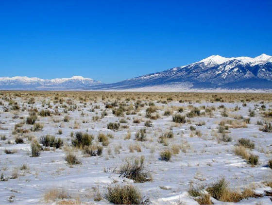
Three
5-Acre Lots in San Luis Valley Ranches (SLVR) Unit 21. These lots are four miles off US Highway 160 and about half way between
Blanca and Alamosa. They have year-round access from Costilla County maintained roads, they are flat, with native grasses
and shrubs and they have great 360 degree views.There are no trees and there are no utilities.Well permits are available for "inside domestic use". Waste disposal is by septic system, but composting
toilets can be used for camping. Solar panels with a 100 -watt output have dropped in price from $800 five years ago to $250
today and those are used in this out-lying area.Camping with Travel Trailers and RV's is allowed if waste
tanks are emptied at a commercial dump station, as the one in Blanca 9 miles away.
Lot #1--SLVR Unit 21, Block 22, Lot 7-Cash Price $2350 or $500 Down and $125/mo for 16 mo.
.
Lot #3--SLVR
Unit 21, Block 34, Lot 8-Cash Price $2350 or $500 Down and $125/mo for 16 mo.
Directions: From Fort Garland head west on US 160 through Blanca for
almost 9 miles and after passing Mile Marker 250, turn left on County Road 11. Head south for 3.75 miles
and turn right on Colorado Springs Ave. Zero odometer as you turn. Head west and stop vehicle at odometer 0.7. Lot #1 will
be on your left with 330' frontage along Colorado Springs Ave and 660' deep.Continue west and stop vehicle again as odometer turns over 1.0. Lot #2 will be on your right with 330' frontage
on Colorado Springs and 660' deep.Continue west and
right after odometer 2.6, turn left on Beular and turn right at the dead end.It is possible that this
road is overgrown since the road went in more than 40 years ago. There are several alternate routes to this lot. Check Location
Map for other possibilities. Here are the two corners of Lot #3 along Lamar: NW Corner 37.40935N; -105.62454WSW Corner37.40849N; -105.62454WWe live in the Denver area, but spent almost half of our time is Fort Garland during spring,
summer and fall.We would be happy to show you these lots, if you make an appointment. For our Appointment
Calendar click Contact Us above. One more thing: While making monthly payments,
it is ok to camp on the land.But we require full payment before starting construction.
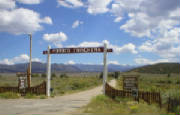
The Entrance to the U Lazy U 2 Parcels
Click to Enlarge
Blanca View from the property
Click to Enlarge
Terrain - looking South
Click to Enlarge
Looking across the parcel- SW view
Click to Enlarge
Another great view of the landscape - SW
Click to Enlarge
West view -- along the fence
Click to Enlarge
Taken from the Property in the grassy area
Courtesy Reservation 8-21-15 Thomas K. from
TX.
Forbes Park Unit J-2, Block 131,
Lot 2348 -- 2.62 acres. Financing not available for this parcel: Best Offer over $32,000
On the side of the Big Lake-- located towards the end of Benton Place, this parcel has access
to the Lake and includes the grassy area shown in some of the photos. The upper portion near the road is very steep
and will require creative and well-planned out road work in order to gain access to the meadow area at the lake edge and to
locate a building site. A parcel at the other end of Benton Pl which is nearer to the main road and also has some amenities
such as power and underground phone in place and is also less sloped has been listed for $59,900. There are mature pines
and an abundance of wildlife in this area. We have several other photos of this property - furnished upon request.
Click for a larger version
Click for larger version
Terrain inside the lot
Click for larger version
Power approx. 900 feet away
Click for larger version
Neighbor Cabin Nearby
Click for larger size
Cabin and neighbor nearby
Click for larger version
Looking West
Click for larger size
Neighbors and mesas to southeast
Click for a larger version
Another view from lot toward east
Click for a larger version
Blanca Massif towering to north
Click for larger version
Snow on eastern mountains in July
Click for larger version
Neighbor with eastern mountain backdrop
Click for larger version
Aerial map with coordinates
Click for larger version
Sold to Shaylena and
Patrick, 7-14-18
SLVR Unit
20, Block 47, Lot 8 -- 5 Acres -- $3,650 Cash/FastPay with $650 down followed by 15 monthly payments of $200
This property has great mountain views, with Blanca Massif to the north,
the Sangre de Cristos to the east, and the San Juans to the west. The parcel is flat with sagebrush ground-cover.
This lot is an ideal candidate for solar power, while a well would likely hit water less than 100 feet down. Alamosa
with its WalMart, Safeway, restaurants, college, hospital, auto-repair shops and other amenities is about 25 minutes west,
while the town of Blanca is about 5 miles northeast.
Driving
Directions: From the western edge of the town of Blanca, drive west on U.S. Highway 160 about 3.8 miles
to a left turn on County Rd. 11 (also known as Mountain View Rd.). Drive south on County Rd. 11 about 2.7 miles to a
right turn on Denver Rd. Follow Denver Rd. 3.5 miles; stop car. Lot is on right, with 330 ft. frontage along Denver
Rd. -- see map below.
Corner stake and Sangre de Cristos to north
Click for larger version
Sold to Gavin T. - CA (11-2-17)
Forbes Park Unit E-1, Block 51, Lot 1082 -- 1.7 Acres -- $5,900 Cash/FastPay,
$6,500 Financed with $1,500 down followed by 25 monthly payments of $200
This
parcel is in an excellent location near the front of the Park and only 900’ from underground power.It has several newer, extra nice cabins nearby.The terrain is gently
sloped with a great number of tall trees, several 2’ in diameter and 60’ high.The parcel
will really take shape if someone uses a chain saw and clears out some undergrowth which will open up the lot to sunshine
and views. Removal of trees on Forbes Park property is subject to approval by a committee.
GPS Coordinates for parcel 1082
Click to enlarge
Click on the map shown to the side to see the SDCR area and locate our Sangre
de Cristo Ranch Mountain Land properties for Sale
SDCR has covenants and is designed for residences although 90% of it is open and not settled consisting of some
permanent residences and many camping sites
It is required to get permits for building from the county - that includes driveways and septic systems
There is no regulation which prohibits camping, although recently the county defined the frequency that
you can camp. Sanitation and open fires are an issue.
You must follow the county
regulations
We urge all prospective buyers to read the covenants thoroughly and be familiar with them. We follow them and
we expect you to also, if you purchase from us!
While you are purchasing land from us, we do not allow building projects,
living on the land, or storing of equipment, supplies, or vehicles. We do allow short-term camping. All county
Rules and Regulations must be followed regarding camping and permitting. If you get our permission, you can put in a
driveway and/or camping pad, with a permit from the county. There might be a few exceptions, such as keeping a fire-pit
on the property which we can allow on an individual basis.
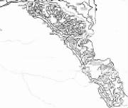
SDCR Map
CLICK FOR A LARGER FULL SCALE VERSION
There are approximately 9,000 parcels of land in SDCR.
Click this map to see the UNIT
location of land that you might be interested in
All lots are north
of 14th Street and between Savage and Weaver Avenue. The town requires a minimum of two lots to build a residence. Water,
Sewer and Electric is nearby and connecting to the town water and sewer is mandatory. Connecting to Blanca town utilities
is a real bargain compared to the Colorado Front Range where tap fees often exceed $50,000. We are only selling these in
groups of two.
To look
at an aerial map for the little town of Blanca , go to Google Earth and enter 81123 Blanca in the search pane.
We
started with 39 town lots and have 3 left in July of 2016. (50'x140') available Two lots cost $1,800;
As stated, you must buy TWO adjacent to qualify for sewer and water hook-up.
Remaining three properties
Click to Enlarge
View of Blanca Massif along Mitchell Rd.
Click for larger version
Mt. Home Reservoir looking down Schieffelin Rd.
Click for larger version
Pinions and openings on this very build-able lot
Click for larger version
Blanca Massif view from clearing at center of lot
Click for larger version
Looking east up Schieffelin Rd. at Henry Rd.
Click for larger version
North view from corner along Schieffelin Rd.
Click for larger version
Northeast mountain view from middle of lot
Click for larger version
Another view of Blanca Massif further back on lot
Click for larger version
SDCR Unit D-2, Block 193, Lot 3620-- 5.413 acres -- $15,500 Cash/FastPay, or $17,000 Financed with $6,000 down and 55 monthly payments of $200 -- CLOSE TO POWER
This
property at Schieffelin Rd. and Mitchell Rd. has plenty of flat, wooded building area, with incredible Blanca Massif views
to the north as you walk toward the north part of the lot. A neighbor to the west has a power box on Schieffelin about
500 ft. from this parcel. This lot would make an excellent permanent residence, or a nice place to put a cabin with
year-round accessibility, views, natural openings in the Pinion trees and plenty of peace and quiet. The little town
of Fort Garland is a short drive away, with its two gas stations, four restaurants, grocery store, Post Office, liquor store
and hardware/lumber shop.
Driving
directions: From Fort Garland, head east on U.S. Hwy 160 for 1.8 miles and turn right through the Trinichera
Ranch entrance. Head south on Trinchera Ranch Rd. for 2.7 miles to a left turn on Schieffelin Rd. Drive 1.2 miles to
Mitchell Rd. Lot is on left side, extending from Mitchell along Schieffelin for about 470 ft., with about 740 feet along
the eastern boundary and 800 feet along the western edge. See map below for shape and coordinates.
SDCR Unit D, Block 68, Lot 902- 5.139 acres - Cash/FastPay price: $5,400 - Financed price: $6,000, with $2,000 down and 32 monthly payments
of $125 -- PRICE REDUCED!
This
gently-sloped west-facing parcel has beautiful mountain and Valley views, and is located 10 minutes from the small town of
Fort Garland with its two gas stations (one with a mechanic on duty), Post Office, grocery store, hardware/lumber store, three
restaurants and liquor store. ... more This lot is suitable for a permanent residence
using solar power. Good fishing is a short drive away to Mountain Home Reservoir.
Driving directions:
From Fort Garland, head south on Colorado Hwy 159 for 4 miles and turn left at Mile Marker #29. Head east on County Lane
6 for 2.5 miles and at the 4-way intersection, go straight across and continue on Juarez Road. Drive 1 mile to a right turn
on Bateman, then take first left onto Bateman. Zero odometer and drive 0.2 miles; park vehicle. Lot is on left side of Bateman,
and corners are marked with orange blaze tape.
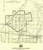
Plat map
Click for larger version
Margie Lane
Click for Larger Version
Northern View
Click for Larger Version
View of Mt. Blanca from parcels
Click for Larger Version
Cul de Sac View
Click for Larger Version
Ridge with pinon trees to the East
Click for larger size
Telephoto Looking South from Parcels
Click for larger size
Aerial View of 785 & 786. 787 was sold
Click for Larger Version
There are some young pinon trees on these lots
Click for larger size
Reserved for Jason A., Sioux City, IA - 3/24/16
SDCR
Unit D, Block 68, Lots 785 and 786, 10.5 Acres -- $13,500 Cash or Fast-Pay. Fast Pay Option requires $6,000 down and $500/mo for 15 months (no interest).
The Installment price is $15,000 with $6,000 down and $250 per month for 40 months. These lots
can be purchased individually also. Lot 785 is $7,200 cash and Lot 786 is $8,910 cash.
Financing is also available. There is a power line crossing both properties and connection
is estimated at less than $2,000.
..
These two adjacent lots are less
than 4 miles from paved Colorado Highway 159 and 8 miles from the little town of Fort Garland with
motels, restaurants, a small super market, service stations and a hardware/lumber yard. Either
lot will make a good site for a permanent residence or a retirement home. Water of good quality, from a
large aquifer, is less than 100’ down resulting in a lower priced well. Special water rights are
attached to SDCR Lots allowing for watering trees, flower, and a garden. With two 5+ acre parcels,
one could be saved for a family member or friend moving in next door. The property is nearly
flat with a few young pinon trees. Additional trees could easily be planted in the sandy soil. Both lots can be accessed
from Margie Lane or from a cul-de-sac at the end of Mellick Road. Connection to electric power will be less than $2,000, since there
is a power line crossing both lots. This area percs well for septic and septic permits are available. Alamosa is 32 miles
west and has a Super Walmart, a Safeway, a Kroger Store, a Walgreens, a medical center and many nice
restaurants. It’s a short drive to the San Isabel National Forest and the
Rio Grande National Forest with hunting for turkeys, elk, and mule deer. The Sand Dunes National Park
is 30 miles to the northwest. There is good fishing for rainbow trout in Mountain Home Reservoir 4.5
miles to the north. There is great scenery, climate, and people in this area to enjoy for retirees or vacationers.
..
Directions: From
Fort Garland, head south on CO 159 for about 4 miles and turn left at Mile Marker # 29. Head
east for three miles on County Lane 6, and at intersection take right to Bateman and then the next
right ( along the power-line) to Margie Lane. Zero odometer as you turn on Margie. Head south
on Margie and after odometer reading 0.6, turn left on driveway Leading to Mellick Circle. Then consult attached plat maps
for property boundaries.
Plat map of the two parcels
Click for Larger Version
Trees and nearby ridge
Click for larger version
Fiber-optic cable and power pole on lot
Click for larger version
Lot seen from Winding Rd.
Click for larger version
Nice big Pinion on lot
Click for larger version
House on lot to west on Winding Rd.
Click for larger version
Neighbor across Winding Rd.
Click for larger version
Sold - Sharron 3/14/16
SDCR
Unit E-2, Block 208, Lot 3958 — 5.56 Acres -- Cash or Fast-Pay Price $9,900. Fast Pay requires $3,900 down and
12 monthly payments of $500. Financed price $11,000 with $4,000 down and 35 monthly payments of $200. There
is no interest with our Fast-Pay Option. Power along Winding Rd.
This is a residential parcel with a power
line crossing the property. It is located in an area with about 15 year-round residents.
From this parcel it is only 1.4 miles to the paved Trinchera Ranch Road and 8 miles to the Fort Garland
Post office and store.It should be a great lot for a full time retirement home or for a second home or
cabin away from the city. Photos of homes are neighbors in the area- shown as a sample of the type of housing
being used in the area.
The lot has a gentle upslope.It has a 400’ frontage
on Winding Road and goes about 600 ‘ uphill. The upper 150’ of the property has a nice stand of pinon trees and
that would be a nice location for a shady gazebo.
The Costilla
County Assessor has valued this parcel at $12,000 which results in a property tax of $180/year. Even with a $100,000 home,
the taxes usually run under $600 per year.
Directions: From Fort Garland, take U.S. Highway 160 east
for about 1.8 miles to a right turn into the Trinchera Ranches. Follow Trinchera Ranch Rd. about 2.7 miles to a left
turn at Scheffellin. Take Scheffellin to the end, then turn right on Frelinghuysen. Follow Frelinghuysen about
0.4 miles to a left turn at Winding Rd., then drive 0.4 miles. Lot is on left -- see map below.
Plat map
Click for a larger version
Coordinate map
Click for larger version
Southwest marker, Rattle Snake Mesa in background
Click for larger version
Beautiful trees on lot, seen from Winding Rd.
Click for larger version
Unit 10, Block 7 Lot 3 Photos-
Click to enlarge - more furnished on request
Click for larger version
Click for larger version
Click for larger version
Click for larger version
SPRING SALE - 10% OFF THE CASH PRICE IF YOU
CAN CLOSE BY JULY 1, 2016
SDCR Unit
T, Block 145, Lot 2608 -- 5.33 Acres -- $13,500 Cash or $15,000 with financing requiring $6,000 down and $250 mo. for 40
months -- POWER ALONG ROAD
This property has
beautiful and awe-inspiring views of Blanca Massif and other mountains in the surrounding area. It is wooded with mature
pinon trees, with power running along Ice House at the lower boundary of the lot. Elevation along Ice House is about 8,125',
while the top of the property is at about 8,200'. Though this parcel is tucked-into a secluded pocket of the SDCR, Ft. Garland
(with groceries, Post Office, gas and several restaurants) is just a 5-minute drive away. A well on nearby Lot 2521 is listed
with the County at 157' depth. This lot is very adaptable for a driveway and building pad.
Directions: From Ft. Garland, head east on Highway 160 about 1.8 miles to the Trinchera Ranches
entrance. Follow Trinchera Ranch Rd. to the first right turn, at Hodge Rd. Hodge dead-ends into Paine; turn right. Follow
Paine about 1.5 miles to Ice House Rd.; turn left, stop, zero odometer, and drive about 0.7 miles and stop car. Lot 2608
straddles the bend in Ice House, with 190' uphill, 270' downhill.
The view to the north of Mt. Blanca from this area
Click for a larger version
A look towards the Sand Dunes
Click for a larger version
Typical MH life in this area
Click for a larger version
MAP WITH LOTS MARKED IN GREEN
Click for a larger version
SECOND LOCATOR MAP
Click for a larger version
Typical Vegetation in Summer
Click for a larger version
Looking toward Blanca Massif from SLVR 13.6.3
Click for full size
Click for full size
Looking south-east into the Valley
Click for larger size
Most trees are pinons with a few cedars mixed in
Click for larger size
Looking towards the area - landmarks shown
Click for larger version
Road to the Mt. Blanca trail-head/Lake Como
Click for a larger version
Rattlesnake Mesa to north, from Nogales Rd.
Click for larger picture
Blanca Massif from center of lot
Click for larger picture
Mature pinon trees cover this lot
Click for larger picture
Natural building area at center of lot
Click for larger picture
Snow-capped peaks above pinon trees
Click for larger picture
Another view of Blanca Massif
Click for larger picture
Reserved by Charles & Ashley M. from
TX on 9/27/14
SDCR Unit J,
Block 112, Lot 1807 -- 5.16 Acres: Cash or FastPay price: $11,700. Financed price: $13,000, with $3,000 down and 45
payments of $250. FastPay option: $6,000 down with 12 monthly payments of $475.
This heavily-treed lot has great views of Blanca Massif and Rattlesnake Mesa to the north, and is ideal for a
year-round residence, hunting cabin or camping spot. There is a natural building area at the center of the lot extending to
the south boundary, with mature Pinons offering beauty and seclusion. Mostly-flat terrain is perfect for a driveway from the
southwest corner at Nogales Rd. SDCR residents qualify for an augmented well-permit which allows for watering a small garden.
County records indicate well-depths on nearby Unit J lots averaging less than 300 feet.
Directions: From Ft. Garland, drive 4.7 miles to Mile Marker #29, turning left onto County
Rd. 6. Go up County Rd. 6 about 2.5 miles to a 4-way intersection; turn left, remaining on County Rd. 6. After 0.9 miles,
turn right on Luke Rd. Follow Luke another 0.9 miles to a right turn at Nogales. Lot begins about 0.15 miles on left and runs
610 feet along Nogales -- corners are marked with orange blaze tape.
Plat map for Lot 1807
Click for larger picture
Winter view north west from large parcels
Typical view north from this area
Click for a larger version
42 Acre Parcel with Power
Click for larger size
Detailed map -- will blow up when you click
Click for larger version
Survey Plat for 41.63 Acres
Click for a Larger Version
Parcel photos - taken November, 2015 by Karen Sattler
Sale: $17,000 Cash or Fast-Pay - with $8,000
down and 6 quarterly payments of $1,500. Financed price is $18,900 with $6,900 down and 60 monthly payments of $200.
There is no interest with either option.
For Sale: Sangre De Cristo Ranches Unit C2, Block 189,
Lot 3479 -- 5.05 Acres
Sales Price: $20,900
This property is owned by one of our customers from Minnesota, who bought the
land from us 9 years ago. They’ve enjoyed the place for many years, but find that now that their children have
grown older, they no longer visit as frequently as they did in the past and decided to sell.
At the end of a nice long driveway - this small one room
cabin sits surrounded by 1,000 year old pinon trees and affording spectacular views of the Sangre De Cristos, including the
Blanca Massiff. The finished cabin was built about 5 years ago, is insulated, has a privacy room for the toliet
and includes a 500 gallon water tank (stored inside during the winter and seen in the photos) and a septic holding tank outside.
The owner has used solar panels and batteries in the past for power. There are two outside areas that are suitable for
parking or additional camping. Although isolated and private, this parcel is less than 5 miles from the small town of
Ft. Garland with a grocery store, Post Office, gas stations, several restaurants and two motels.
Directions: From Ft. Garland head east on U.S. Hwy 160 1.8 miles to Trinchera
Ranches entrance. Turn right and follow Trinchera Ranch Rd. 1.1 miles to a left turn at Beekman. Go up Beekman
0.9 miles to a right turn at Slaughter. Take first right at McLaughlin, then drive 0.4 miles to a left turn at
Heltzer. Follow Heltzer past Bixby -- look for where the Pinon trees come into view on the left side of the
road. Driveway entrance is marked by two wooden posts and with a chain.
SLVR Unit 13, Block 6, Lot 4 -- 5 Acres -- Alamosa
County -- $8,100 Cash or $9,000 with $3000 down and 33 monthly payments of $200. (Lot 4
& 5 sold to Richard and Amy D. from MO on 8-28-13)
This land is on the lower slopes of the Mount Blanca Massif, 3 miles from paved CO 150 and 5.5 miles from the
little town of Blanca on US Hwy 160. The last half mile to the property is rugged with rocks and dips, and requires slow speeds
and 7" minimum ground clearance. A 4 wheel drive vehicle is recommended. Unit 13 is surrounded by public land. The San
Isabel National Forest boundary is 1/2 mile away and BLM land is 1/4 mile away-both in easy walking distance. Tobin Creek
flows 1/2 mile to the east and some locals use that as their water source. The Rio Grande National Forest is also nearby.
The Forest Service Access Road leading up to Lake Como (Alpine Lake) and several of the 14,000' peaks is less than 3 miles
away. The Sand Dunes National Park Entrance is 18 miles away, and San Luis Lakes, with great rainbow trout fishing is 22 miles
away. This is a great area for vacationing and hunting but we would not recommend it for a permanent residence. There
are two mountain homesteaders living in the area.This lot is on a gentle, south facing down slope, ideal for solar power.
People in the immediate area are using water tanks and cisterns. There are no wells nearby, but it is estimated that depth
to good water would be less than 250'. Composting toilets, incineration toilets and septic systems are used in Alamosa County. Directions:
From US 160 in Blanca head west on 160 for almost six miles and turn right on Colorado Hwy 150, the Sand Dunes Road. Zero
odometer as you turn north on 150. As odometer turns over 2.5 miles, take the next right turn and head east on 18th St for
2.44 miles. Turn left and then take the trail to the left, along the fence. Zero odometer again as you start on trail. Head
north-west and then north for 1 mile and turn right on unmarked 22nd St. Zero odometer again as you turn. Near odometer 0.2,
watch for driveway to your left and stop vehicle. 50 ' past that point. You will be near the east end of 13.6.5, which will
be on your right. There is a long pole that can be seen marking the corner between lots 4 and 5.
WELL MARKED PLAT MAP OF PARCELS
CLICK TO ENLARGE THIS MAP
Sold
to Scott T. from Missouri, 6/27/13
SDCR Unit B-3 Block 278 Lot 6281-- 5.04 Acres -- Cash or FastPay: $16,200.
Financed price: $18,000, with $8,000 down and $250 a month for 44 months. With our Fast-Pay Option, a down
payment of $8,100 is required followed by 12 monthly payments of $675.
.
This is a great lot. It is a corner property at Malcolm and Jacquez .There is a small stream flowing
across the street. This area has large, alpine meadows with outstanding views toward Trinchera Peak and the southern portion
of the Sangre De Cristo Range.Here, the locals have their cabins and it is there where they go elk huntingin
October and November.
.
But please note: This area is not suitable for a year-round residence.They get up to 20 feet
of cumulative snowfall and the only way to get there in the winteris by snowmobile. But once the snow has
melted, there are green meadows with alpine flowers and tall, healthy trees.
Directions:From Fort Garland, head south
on CO 159 for about 11 miles. Watch green Mile Markers. After Mile Marker #22, watch for Jasper Road on your left.
Turn on Jasper, take the next right and after almost ½ mile, turn left on Rito Seco. Zero odometer as you turn
on Rito Seco. Head east on Rito Seco. Near odometer 4.7, pass buildings of the closed Battle Mountain Gold Mine.
Near odometer 5.3, turn right unto Forbes Road. Zero odometer again as you turn on Forbes. Head up Forbes for
3.6+ miles and turn right on Malcolm. After 0.3 miles Malcom turns left. Continue on Malcom for a little
over two miles dropping from 10,000’ elevation to about 9400’. Stop at the corner of Jacquez and Malcom.
Lot will be on your left -- check plat map to locate the property.
Aerial map
Click for full size map
Plat map
Click for larger picture
Cabin on Jacquez across from lot
Click for larger picture
Looking up Jacquez from top of lot
Click for larger picture
Nearby snow-capped mountains
Click for larger picture
Nearby meadow seen from top of lot
Click for larger picture
Used by Permission of the Owner
Area near B-3 on September 1, 2012
Looking down Jacquez toward Malcolm
Click for larger picture
Used by Permission of the Owner
Aspens in the high country - click for larger view
Another view of mountains
Click for larger picture
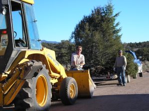
Small Equipment on the job.edit test
The Big Cat Clearing a Driveway in the high county. edit
Rodger and Tim getting ready to plant trees
Sold
to Roger O. from San Angelo, TX
SDCR Unit E, Block 82, Lot 1069 -- 5.19 Acres -- Cash price: $8,100. Financed price:
$9,000 with $4,000 Down and then $141 per month for 41 months. This parcel can be purchased with
our Fast-Pay Option, without interest, if the entire Cash amount is paid within one year.
This lot has amazing views of Blanca Massif to the north, nearby alpine
areas to the east, and the San Luis Valley to the west, with plenty of southern exposure for solar panels and picture
windows. This parcel is ideal for a year-round residence, a hunter's cabin or camping. At about 8,300' elevation,
this lot has many mature trees, with several excellent driveway and building-pad options to choose from.
An augmented well permit is available, allowing you to water a small garden, flowers and trees. The town of Ft. Garland
is 11 miles away, offering a grocery store, Post Office, two service stations, two motels, four restaurants, a hardware
store and a lumber yard.
.
Click
HERE to take a YouTube tour of this beautiful lot.
.
Directions: From Ft. Garland, take Hwy. 159 south 5.7
miles to a left turn at CO County Rd. 6. Follow County Rd. 6 about 2.5 miles to a 3-way intersection
with Bateman (on the right) and Juarez -- continue straight on Juarez 2.7 miles to a left turn at Lee
Way. Take first right on Hotchkiss. Lot 1069 is about 1/2 a mile up Hotchkiss on the right, marked along
the road wiith green metal posts and orange tape.
A restful place to take in the views
Click to Enlarge
A view to the southeast from northeast marker
Click to Enlarge
Looking west along Hotchkiss w/corner markers
Click to Enlarge
Trees on ridge at back of lot, looking west
Click to Enlarge
Rattlesnake Mesa and Blanc Massif to the north
Click to Enlarge
Potential neighbor to the south
Click to Enlarge
Mike standing at original southeast corner marker
Click to Enlarge
Beautiful view to west across San Luis Valley
Click to Enlarge
Plat Map
Click to Enlarge
Enter subhead content here
PROPERTIES AVAILABLE IN AREAS BELOW- Click
tabs to the left
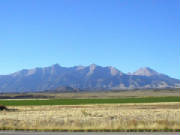
SANGRE
DE CRISTO RANCHES - homesites, cabins, camping sites
ALPINE PROPERTIES - high elevation and limited accessibility
FORBES PARK -- Homesites in a gated community
SAN LUIS VALLEY RANCHES - Camping, cabins, homesites (value-priced)
35 and 40 ACRE PARCELS IN ALAMOSA & COSTILLA COUNTY
Spring thaw - Unit X -
Sattler Mountain Land, Inc. A Colorado Corporation
All Photos on these pages are
Copyrighted
CLICK ANY PHOTO OR MAP BELOW
TO SEE PARCELS AVAILABLE IN THAT
AREA or USE LINKS TO THE LEFT
FORBES
PARK - A GATED COMMUNITY WITH HOMESITES RANGING IN SIZE FROM 1-3 ACRES
SAN LUIS VALLEY RANCHES- NORTH AND SOUTH
OF HWY 160 NEAR BLANCA, CO
SANGRE DE CRISTO RANCHES- EAST AND SOUTH
OF FORT GARLAND
LARGE PARCELS- OVER 35 ACRES in Alamosa and Costilla Counties